| Glossary | related links | Feed back | Events | Contact Us |
Our vision is to generate a support system equipped to access, use, analyse, orient and develop action plans, on varied sectors for use by varied departments for systematic Policy Making & Evaluation and to better enable the Planning Department meet Social, Economic, Financial, and Natural Climatic challenges.
TSDPS is a registered society under Societies Registration Act 1898/ 2001. On bifurcation of state in terms of G.O. Ms. No.20. REVENUE(REG.II) Department Dated 18-08-2014. The erstwhile TSDPS has been taken over from 01.11.14 and is functioning separately.
Background: The society has been established way back in 2003 with the assistance of World Bank in 2003 under APHM & ECR project under the planning department. Later on, on closure of the project a separate autonomous society has been established on 01.3.2003 under the administrative control of Planning Department. The society was entrusted to take up Disaster Mitigation studies relating to “Rainfall-Run-off and Flood Forecasting, Cyclone model for Track, Wind and Storm Surge forecast to improve the early warning capabilities of State on natural disasters. The society in course of its working also started studies on Coastal Zone Management, Delta Water management, Preparation of Disaster Management Plans related to Cyclone, Drought and Earthquakes as part of its long term mitigation measures.
The Society was restructured on 01.4.12 to support Planning department activities pertaining to Result Framework based outcome monitoring to support planning and growth forecasting through professional support, mainstreaming the disaster mitigation and networking with various national and international organizations.
Building a strong, reliable and accurate data on weather related parameters and real time dissemination system that can reach out to the communities at the lowest territorial units using all possible types of communications systems
Generating vulnerability mapping for all types of disasters for the State, District, Mandals and Villages and prepares Disaster Mitigation plans and integrates them with the regular planning process at State, District and Panchayat levels
Analysing climate change impacts in the state and preparing State, District, Mandal and Panchayat level climate change mitigation and adaptation plans with active participation of all stakeholders
Carrying out pilot projects and research in emerging and critical areas of state’s economic and social sectors with participation of stakeholders towards supporting economic and social sector planning in the state
Generating Sector Wise appraisals and reviews with the help from the current data and database (both tabular & GIS based) generated from associate units of the Planning Department, that will identify the gaps and generate action points
Generating alternative innovative strategies, designs and analysis on varied issues and sectors will be encouraged and the same shared with the public at large through the website
Conducting gap and growth analysis of the State’s Economic and Social Sectors and carry out modelling, making projections, forecasting and result framework based outcome monitoring to support Annual and Five Year Planning in the state in coordination with the Planning and Monitoring Units of line Departments
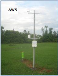
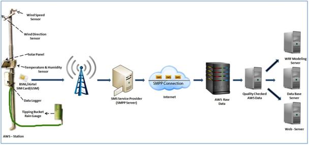
Weather Monitoring Unit: focus on automatic real time acquisition and dissemination of weather related parameters and involves in running of weather forecast and flood models and Drought monitoring. To facilitate data collection TSDPS has installed 1044 Automated Weather Stations (AWS), 64 global radiation sensors and 41 soil moisture sensors and, across the state to acquire data on real time basis. The AWS measures 6 weather parameters - Rainfall, Wind Speed, Wind Direction, Pressure, Humidity and Temperature in addition it also measures Global radiation and soil moisture at desired location at every one hour interval and transmits it in the form of SMS using GSM technology. Presently, at least one AWS for each mandal is installed in a grid of 10km X 10km. River gauges measures the water level in the river at that particular location and transmits data at hourly interval. |
|
Stake holders: 1.Agricultural farmers2.Agricultural Insurance Corporation 3.IMD 4.NRSC 5.TRAC 6.Agricultural University 7.Agriculture Department 8.Disaster Management Department 9.Irrigation department 10.DES |
 |
The data is being used by stake holders for proper planning and implementation of varied government programs and schemes. AWS data is also being used by Agriculture Insurance Company of India for implementation of Weather Based Crop Insurance Scheme (WBCIS) for various crops in the districts. |
|
 |
|
| AWS – Data Flow | |
Evaluation & Monitoring Unit: |
|
The Government has recognized the need for an effective use of credible evaluation as a tool to benchmark the state flagship programmes/schemes and to refine public policies with prudent and optimal use of resources for maximizing the intended and measurable outcomes and citizen satisfaction.
In recognizing the significance of Evaluation & Monitoring of the government Programmes and Schemes, the TSDPS is entrusted with the task of conducting gap and growth analysis of the State’s Economic and Social Sectors, carrying out evidence based studies to improve programme design and delivery.
Recently, the TSDPS has also taken the task of Evaluation study on Post Project Evaluation of 47 Projects of first batch 2009-10 of IWMP and these (47) watershed projects are located in (17) districts of the State is under process.
|
|
Development Planning Unit: assists in steering the planning department in charting a planned development process in the state. The focus is on initialising studies, research, reviews, appraisals and data base on key growth parameters in the state. The Society collects data from different departments / schemes / programmes, analyses growth patterns and trends, identifies gaps and areas of concern, collates interdepartmental data to get both a Macro and Micro picture of the functioning of sectors and programmes that aid in planning the key areas of focus in terms of funds, allocations, schemes, locations and types of interventions to be undertaken. The Planning activity with the support of a specialised unit is poised to become a professional exercise where trends and concerns pinpoint the focus areas and assist in preparing the action plans. The Planning exercise can with this focus transform from a mechanical and routine exercise into a demand driven, target oriented and effective tool that can hugely enhance developmental prospects of the state. Aims and objectives of the Society:
Departmental ACTIVITIES
Monitoring & Evaluation of Government Schemes
District Knowledge and Innovation Centres (DKICs)
|
|